Datasets 3rd Edition
SAMPLE DATA DOWNLOAD
Open Source GIS: A GRASS GIS Approach
Markus Neteler, Helena Mitasova
3. Edition 2008, 426 pages
ISBN: 978-0-387-35767-6
Springer, New York
Book Series: The International Series in Engineering and Computer Science: Volume 773
Sample data as used in the book “Open Source GIS: A GRASS GIS Approach”, 3rd edition. Find detailed dataset descriptions within the book. Please let us know about any problems with these data.
Dataset overview
Take a tour through the data set with many screenshots:
H. Mitasova, M. Neteler, 2007: OSGeo sample dataset for research, development and education. Proc. Free and Open Source Software for Geospatial (FOSS4G) conference, 24-27 Sep 2007, Victoria, Canada [PDF]
Dataset details
| Dataset name | Download |
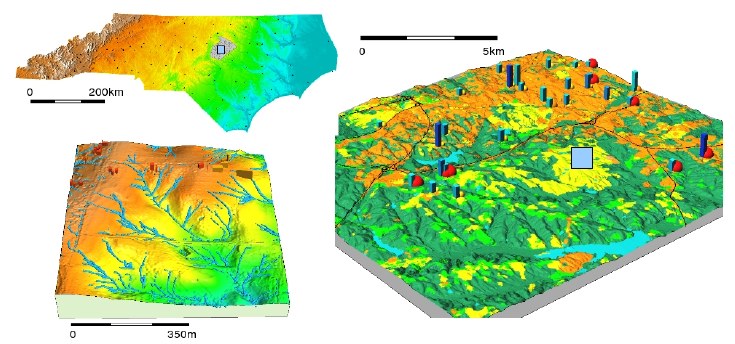
| North Carolina, USA (OSGeo Edu dataset) | We developed a completely new free geospatial dataset and substituted all Spearfish (SD) examples in the previous editions with this new, much richer North Carolina (NC, USA) data set. This data set is a comprehensive collection of raster, vector and imagery data covering parts of North Carolina (NC), USA (map), prepared from public data sources provided by the North Carolina state and local government agencies and Global Land Cover Facility (GLCF). Data are provided at three hierarchical levels:
The data set includes section of the NC capital city Raleigh and its surroundings. The coordinate system of the ready-to-use GRASS data set is NC State Plane (Lambert Conformal Conic projection), metric units and NAD83 geodetic datum. Additional data are provided in geographic coordinates and NC State Plane, english units (feet) in various external formats.Included maps:
The examples throughout this book are based on this data set. Furthermore, new derivative maps are generated and explained. North Carolina Data set download:
|
| Maas (Meuse) river bank soil pollution data(Chapter 10) |
|